Thank you for supporting this site ❤️
Make a donation
Make a donation
Gear up for your next adventure:
As an Amazon Associate, this site earns from qualifying purchases at no extra cost to you.
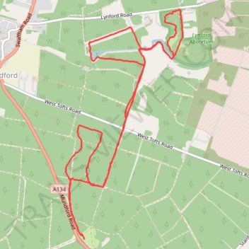
Lynford Walk
- Distance: 6.3 mi
- Elevation gain: 230 ft
- Maximum elevation: 135 ft
- Elevation loss: 226 ft
- Minimum elevation: 52 ft
- Moving time: 2 h 52 m
- Moving speed: 2.2 mph
- Maximum speed: 6.6 mph
- Total time: 3 h 3 m
- Global speed: 2.1 mph
Interactive trail map
Thank you for supporting this site ❤️
Make a donation
Make a donation
Gear up for your next adventure:
As an Amazon Associate, this site earns from qualifying purchases at no extra cost to you.
Trail profile
- Distance: 6.3 mi
- Elevation gain: 230 ft
- Maximum elevation: 135 ft
- Elevation loss: 226 ft
- Minimum elevation: 52 ft
- Moving time: 2 h 52 m
- Moving speed: 2.2 mph
- Maximum speed: 6.6 mph
- Total time: 3 h 3 m
- Global speed: 2.1 mph
Thank you for supporting this site ❤️
Make a donation
Make a donation
Gear up for your next adventure:
As an Amazon Associate, this site earns from qualifying purchases at no extra cost to you.
About this trail
Name: Lynford Walk trail, distance, elevation, map, profile, GPS track
Coordinates: 52.49384 0.66682 52.51548 0.68486
Thank you for supporting this site ❤️
Make a donation
Make a donation
Gear up for your next adventure:
As an Amazon Associate, this site earns from qualifying purchases at no extra cost to you.