Thank you for supporting this site ❤️
Make a donation
Make a donation
Gear up for your next adventure:
As an Amazon Associate, this site earns from qualifying purchases at no extra cost to you.
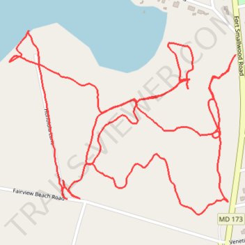
Weinberg Park
- Distance: 2.9 mi
- Elevation gain: 128 ft
- Maximum elevation: 66 ft
- Elevation loss: 128 ft
- Minimum elevation: 7 ft
- Moving time: 1 h 14 m
- Moving speed: 2.4 mph
- Maximum speed: 4.4 mph
- Total time: 1 h 24 m
- Global speed: 2.1 mph
Interactive trail map
Thank you for supporting this site ❤️
Make a donation
Make a donation
Gear up for your next adventure:
As an Amazon Associate, this site earns from qualifying purchases at no extra cost to you.
Trail profile
- Distance: 2.9 mi
- Elevation gain: 128 ft
- Maximum elevation: 66 ft
- Elevation loss: 128 ft
- Minimum elevation: 7 ft
- Moving time: 1 h 14 m
- Moving speed: 2.4 mph
- Maximum speed: 4.4 mph
- Total time: 1 h 24 m
- Global speed: 2.1 mph
Thank you for supporting this site ❤️
Make a donation
Make a donation
Gear up for your next adventure:
As an Amazon Associate, this site earns from qualifying purchases at no extra cost to you.
About this trail
Name: Weinberg Park trail, distance, elevation, map, profile, GPS track
Coordinates: 39.15192 -76.48950 39.15699 -76.48144
Topography: Anne Arundel County topographic map, elevation, terrain
Thank you for supporting this site ❤️
Make a donation
Make a donation
Gear up for your next adventure:
As an Amazon Associate, this site earns from qualifying purchases at no extra cost to you.