Thank you for supporting this site ❤️
Make a donation
Make a donation
Gear up for your next adventure:
As an Amazon Associate, this site earns from qualifying purchases at no extra cost to you.
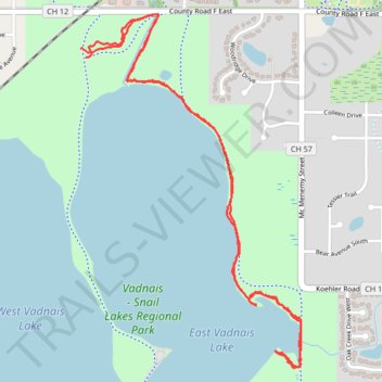
Vadnais Lake Side Paths
- Distance: 3.4 mi
- Elevation gain: 154 ft
- Maximum elevation: 942 ft
- Elevation loss: 161 ft
- Minimum elevation: 886 ft
- Moving time: 1 h 6 s
- Moving speed: 3.4 mph
- Maximum speed: 15.5 mph
- Total time: 1 h 6 s
- Global speed: 3.4 mph
Interactive trail map
Thank you for supporting this site ❤️
Make a donation
Make a donation
Gear up for your next adventure:
As an Amazon Associate, this site earns from qualifying purchases at no extra cost to you.
Trail profile
- Distance: 3.4 mi
- Elevation gain: 154 ft
- Maximum elevation: 942 ft
- Elevation loss: 161 ft
- Minimum elevation: 886 ft
- Moving time: 1 h 6 s
- Moving speed: 3.4 mph
- Maximum speed: 15.5 mph
- Total time: 1 h 6 s
- Global speed: 3.4 mph
Thank you for supporting this site ❤️
Make a donation
Make a donation
Gear up for your next adventure:
As an Amazon Associate, this site earns from qualifying purchases at no extra cost to you.
About this trail
Name: Vadnais Lake Side Paths trail, distance, elevation, map, profile, GPS track
Coordinates: 45.05087 -93.09892 45.06464 -93.08676
Topography: Ramsey County topographic map, elevation, terrain
Thank you for supporting this site ❤️
Make a donation
Make a donation
Gear up for your next adventure:
As an Amazon Associate, this site earns from qualifying purchases at no extra cost to you.