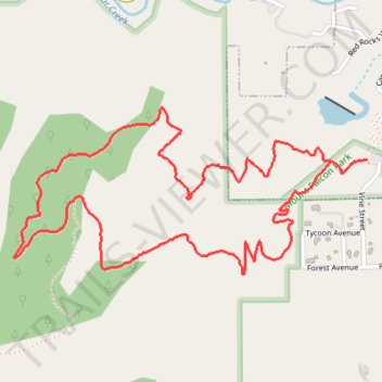
Turkey Trot Trail Loop
From the Mount Falcon Morrison Trailhead, the route sets out on Turkey Trot Trail above Vine Street, leaving the park edge for open foothill slopes, low scrub, and scattered pines with early views toward Morrison, Red Rocks Park, and the Denver plain.
It continues west on Turkey Trot Trail as the loop wraps around the Mount Falcon flank, crossing rocky sidehill terrain and quieter wooded stretches toward the outer edge of the park above Bear Creek Canyon.
Joining Castle Trail for the return, the itinerary heads back across sunlit hillsides and shaded forest to the trailhead, offering a compact Mount Falcon circuit that blends Front Range scenery, red-rock vistas, and the peaceful character of Turkey Trot Trail.
#Hiking #Loop #Mountain #Forest #Nature #Foothills
- Distance: 3.3 mi
- Elevation gain: 902 ft
- Maximum elevation: 6,788 ft
- Elevation loss: 906 ft
- Minimum elevation: 6,014 ft
- Moving time: 1 h 15 m
- Moving speed: 2.6 mph
- Maximum speed: 3.7 mph
- Total time: 1 h 20 m
- Global speed: 2.4 mph
Interactive trail map
Trail profile
- Distance: 3.3 mi
- Elevation gain: 902 ft
- Maximum elevation: 6,788 ft
- Elevation loss: 906 ft
- Minimum elevation: 6,014 ft
- Moving time: 1 h 15 m
- Moving speed: 2.6 mph
- Maximum speed: 3.7 mph
- Total time: 1 h 20 m
- Global speed: 2.4 mph
About this trail
Name: Turkey Trot Trail Loop trail, distance, elevation, map, profile, GPS track
Start: Castle Trail, Morrison, Jefferson County, Colorado, 80465, United States (39.64678 -105.19741)
End: Castle Trail, Morrison, Jefferson County, Colorado, 80465, United States (39.64683 -105.19686)
Coordinates: 39.64292 -105.21265 39.64863 -105.19686
Topography: Jefferson County topographic map, elevation, terrain
Other hiking, mountain biking, running and outdoor activity trails
Click on a trail to view its statistics, map and profile.
Turkey Trot Trail Loop via Castle Trail in Mount Falcon Park
United States > Colorado > Jefferson County > Morrison
From the Morrison Trailhead, the route starts on Castle Trail, leaving the edge of town for open foothill slopes, switchbacks and early views toward Red Rocks and the Denver skyline. It then joins Turkey Trot Trail, a hiker-focused section that climbs and contours through quieter pine, scrub and rocky hillside…
Distance: 3.4 mi • Elevation gain: 919 ft • Maximum elevation: 6,788 ft