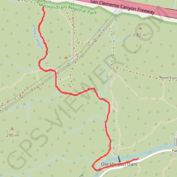
Oak Canyon Trail in Mission Trails Regional Park
The Oak Canyon Trail in Mission Trails Regional Park offers a peaceful and scenic hike that is perfect for those looking to escape the bustle of the city. As you walk along the path, you’ll pass through lush oak groves and cross small bridges, with the occasional seasonal waterfall providing a serene highlight, especially during the winter and spring months when the creek is flowing. The trail is relatively flat, with minimal elevation gain, making it a great choice for beginners or those seeking a more relaxed hike. #Hiking #Nature
- Distance: 3.2 mi
- Elevation gain: 292 ft
- Maximum elevation: 518 ft
- Elevation loss: 292 ft
- Minimum elevation: 269 ft
- Moving time: 1 h 35 m
- Moving speed: 2.0 mph
- Maximum speed: 3.1 mph
- Total time: 1 h 37 m
- Global speed: 2.0 mph
Interactive trail map
Trail profile
- Distance: 3.2 mi
- Elevation gain: 292 ft
- Maximum elevation: 518 ft
- Elevation loss: 292 ft
- Minimum elevation: 269 ft
- Moving time: 1 h 35 m
- Moving speed: 2.0 mph
- Maximum speed: 3.1 mph
- Total time: 1 h 37 m
- Global speed: 2.0 mph
About this trail
Name: Oak Canyon Trail in Mission Trails Regional Park trail, distance, elevation, map, profile, GPS track
Coordinates: 32.83883 -117.05084 32.85187 -117.04138
Topography: San Diego topographic map, elevation, terrain
Other hiking, mountain biking, running and outdoor activity trails
Click on a trail to view its statistics, map and profile.
Grasslands Loop Trail and Oak Canyon Trail in Mission Trails Regional Park
United States > California > San Diego County > San Diego
The Grasslands Trail and Oak Canyon Trail Loop provides a diverse hiking experience. The Grasslands Loop offers expansive views of the rolling hills and chaparral, with opportunities for birdwatching, while the Oak Canyon Trail winds through oak groves along a dry creek bed, showcasing seasonal waterfalls. The…
Distance: 3.8 mi • Elevation gain: 420 ft • Maximum elevation: 594 ft
Kwaay Paay Peak Trail in Mission Trails Regional Park
United States > California > San Diego County > San Diego
The Kwaay Paay Peak Trail in Mission Trails Regional Park offers hikers a rewarding journey through diverse landscapes, including chaparral and manzanita forests. The ascent is steep, with strategically placed stairs aiding the climb. Upon reaching the summit, hikers are treated to expansive views of San Diego…
Distance: 2.4 mi • Elevation gain: 883 ft • Maximum elevation: 1,158 ft