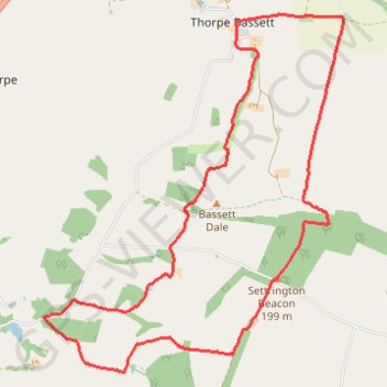
Thorpe Basset Loop
- Distance: 8.0 mi
- Elevation gain: 1,014 ft
- Maximum elevation: 659 ft
- Elevation loss: 1,014 ft
- Minimum elevation: 144 ft
- Moving time: 2 h 6 m
- Moving speed: 3.8 mph
- Maximum speed: 7.2 mph
- Total time: 2 h 9 m
- Global speed: 3.7 mph
Interactive trail map
Trail profile
- Distance: 8.0 mi
- Elevation gain: 1,014 ft
- Maximum elevation: 659 ft
- Elevation loss: 1,014 ft
- Minimum elevation: 144 ft
- Moving time: 2 h 6 m
- Moving speed: 3.8 mph
- Maximum speed: 7.2 mph
- Total time: 2 h 9 m
- Global speed: 3.7 mph
About this trail
Name: Thorpe Basset Loop trail, distance, elevation, map, profile, GPS track
Coordinates: 54.11507 -0.71243 54.14848 -0.66464
Other hiking, mountain biking, running and outdoor activity trails
Click on a trail to view its statistics, map and profile.
Settrington Beacon Loop from Norton-on-Derwent
United Kingdom > England > North Yorkshire > Norton-on-Derwent
Distance: 18.6 mi • Elevation gain: 1,352 ft • Maximum elevation: 659 ft
Rillington - Sherburn
United Kingdom > England > North Yorkshire > Rillington
Via The Wolds Way #Hiking
Distance: 9.7 mi • Elevation gain: 771 ft • Maximum elevation: 594 ft
North Grimston Loop from Norton-on-Derwent
United Kingdom > England > North Yorkshire > Malton
Distance: 13.3 mi • Elevation gain: 656 ft • Maximum elevation: 285 ft