Make a donation
Gear up for your next adventure:
As an Amazon Associate, this site earns from qualifying purchases at no extra cost to you.
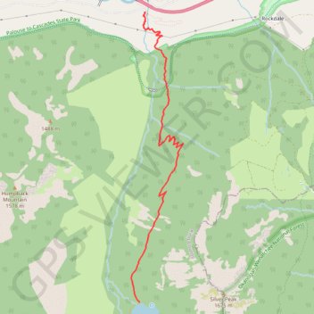
Annette Lake Trail in Mount Baker-Snoqualmie National Forest
The Annette Lake Trail, nestled in the Mount Baker-Snoqualmie National Forest, offers a delightful hiking experience combining serene natural beauty and moderate physical challenge. The journey begins in lush, shaded forests dominated by towering evergreens and progresses past cascading waterfalls, talus slopes, and vibrant wildflowers in season. Upon reaching Annette Lake, hikers are rewarded with tranquil views of its clear, glacier-fed waters framed by Humpback Mountain, Silver Peak, and occasional waterfalls that complete this picturesque setting. #Hiking #Mountain #Forest #Nature #Lake
- Distance: 3.3 mi
- Elevation gain: 1,824 ft
- Maximum elevation: 3,727 ft
- Elevation loss: 151 ft
- Minimum elevation: 1,949 ft
Interactive trail map
Make a donation
Gear up for your next adventure:
As an Amazon Associate, this site earns from qualifying purchases at no extra cost to you.
Trail profile
- Distance: 3.3 mi
- Elevation gain: 1,824 ft
- Maximum elevation: 3,727 ft
- Elevation loss: 151 ft
- Minimum elevation: 1,949 ft
Make a donation
Gear up for your next adventure:
As an Amazon Associate, this site earns from qualifying purchases at no extra cost to you.
About this trail
Name: Annette Lake Trail in Mount Baker-Snoqualmie National Forest trail, distance, elevation, map, profile, GPS track
End: Annette Lake Trail, King County, Washington, United States (47.36053 -121.47495)
Coordinates: 47.36053 -121.47630 47.39281 -121.46786
Topography: King County topographic map, elevation, terrain
Make a donation
Gear up for your next adventure:
As an Amazon Associate, this site earns from qualifying purchases at no extra cost to you.
Other hiking, mountain biking, running and outdoor activity trails
Click on a trail to view its statistics, map and profile.
Annette Lake Trail in Mount Baker Snoqualmie National Forest
United States > Washington > King County
The Annette Lake Trail in Washington's Mount Baker-Snoqualmie National Forest offers hikers a diverse array of natural beauty. Along the well-maintained path, you'll encounter cascading waterfalls, expansive views of Granite and Humpback Mountains, and the serene Annette Lake, which is ideal for a refreshing…
Distance: 7.5 mi • Elevation gain: 2,162 ft • Maximum elevation: 3,737 ft
Northern part of the Pacific Crest Trail (PCT)
United States > Oregon > Klamath County
Hike on the Pacific Crest National Scenic Trail from Crater Lake to Canada Border through Oregon and Washington along the Sierra Nevada and Cascade mountain ranges. #Hiking #Mountain #SierraNevada #Cascade #Nature #Forest #Park #PCT
Distance: 744.6 mi • Elevation gain: 145,367 ft • Maximum elevation: 7,569 ft
Make a donation
Gear up for your next adventure:
As an Amazon Associate, this site earns from qualifying purchases at no extra cost to you.
Annette Lake Trail
United States > Washington > King County
Distance: 7.3 mi • Elevation gain: 2,090 ft • Maximum elevation: 3,730 ft