Thank you for supporting this site ❤️
Make a donation
Make a donation
Gear up for your next adventure:
As an Amazon Associate, this site earns from qualifying purchases at no extra cost to you.
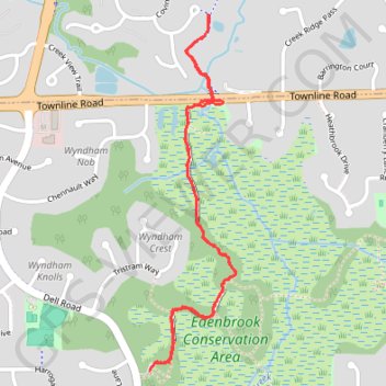
GoMap__2024_11_29__15_09_20
- Distance: 2.2 mi
- Elevation gain: 72 ft
- Maximum elevation: 889 ft
- Elevation loss: 72 ft
- Minimum elevation: 860 ft
- Moving time: 56 m 26 s
- Moving speed: 2.3 mph
- Maximum speed: 22.8 mph
- Total time: 1 h 1 m
- Global speed: 2.2 mph
Interactive trail map
Thank you for supporting this site ❤️
Make a donation
Make a donation
Gear up for your next adventure:
As an Amazon Associate, this site earns from qualifying purchases at no extra cost to you.
Trail profile
- Distance: 2.2 mi
- Elevation gain: 72 ft
- Maximum elevation: 889 ft
- Elevation loss: 72 ft
- Minimum elevation: 860 ft
- Moving time: 56 m 26 s
- Moving speed: 2.3 mph
- Maximum speed: 22.8 mph
- Total time: 1 h 1 m
- Global speed: 2.2 mph
Thank you for supporting this site ❤️
Make a donation
Make a donation
Gear up for your next adventure:
As an Amazon Associate, this site earns from qualifying purchases at no extra cost to you.
About this trail
Name: GoMap__2024_11_29__15_09_20 trail, distance, elevation, map, profile, GPS track
Coordinates: 44.88322 -93.51064 44.89430 -93.50685
Topography: Hennepin County topographic map, elevation, terrain
Thank you for supporting this site ❤️
Make a donation
Make a donation
Gear up for your next adventure:
As an Amazon Associate, this site earns from qualifying purchases at no extra cost to you.
Other hiking, mountain biking, running and outdoor activity trails
Click on a trail to view its statistics, map and profile.
Edenbrook Conservation Area
United States > Minnesota > Hennepin County > Eden Prairie
Distance: 2.3 mi • Elevation gain: 72 ft • Maximum elevation: 889 ft