Hoffman Hills Loop via Skyline, Starwars and Hawk Ridge
- Distance: 3.5 mi
- Elevation gain: 469 ft
- Maximum elevation: 1,234 ft
- Elevation loss: 469 ft
- Minimum elevation: 981 ft
- Moving time: 51 m 2 s
- Moving speed: 4.1 mph
- Maximum speed: 9.9 mph
- Total time: 51 m 2 s
- Global speed: 4.1 mph
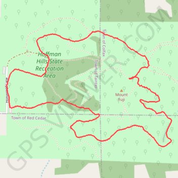
Interactive trail map
Trail profile
- Distance: 3.5 mi
- Elevation gain: 469 ft
- Maximum elevation: 1,234 ft
- Elevation loss: 469 ft
- Minimum elevation: 981 ft
- Moving time: 51 m 2 s
- Moving speed: 4.1 mph
- Maximum speed: 9.9 mph
- Total time: 51 m 2 s
- Global speed: 4.1 mph
About this trail
Name: Hoffman Hills Loop via Skyline, Starwars and Hawk Ridge trail, distance, elevation, map, profile, GPS track
Start: Plantation Trail, Town of Tainter, Dunn County, Wisconsin, United States (44.94434 -91.78278)
End: Plantation Trail, Town of Tainter, Dunn County, Wisconsin, United States (44.94435 -91.78274)
Coordinates: 44.94134 -91.78307 44.95009 -91.76544
Topography: Dunn County topographic map, elevation, terrain
Other hiking, mountain biking, running and outdoor activity trails
Click on a trail to view its statistics, map and profile.
Hoffman Hills Loop
United States > Wisconsin > Dunn County
Distance: 4.1 mi • Elevation gain: 351 ft • Maximum elevation: 1,178 ft