Thank you for supporting this site ❤️
Make a donation
Make a donation
Gear up for your next adventure:
As an Amazon Associate, this site earns from qualifying purchases at no extra cost to you.
Carnarvon Gorge - Big Bend to Gadds
Interactive trail map
Thank you for supporting this site ❤️
Make a donation
Make a donation
Gear up for your next adventure:
As an Amazon Associate, this site earns from qualifying purchases at no extra cost to you.
Trail profile
- Distance: 9.6 mi
- Elevation gain: 2,372 ft
- Maximum elevation: 3,619 ft
- Elevation loss: 1,496 ft
- Minimum elevation: 1,660 ft
Thank you for supporting this site ❤️
Make a donation
Make a donation
Gear up for your next adventure:
As an Amazon Associate, this site earns from qualifying purchases at no extra cost to you.
About this trail
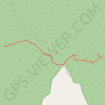
Name: Carnarvon Gorge - Big Bend to Gadds trail, distance, elevation, map, profile, GPS track
End: Carnarvon Great Walk, Mount Moffatt, Maranoa Regional, Queensland, Australia (-25.02527 148.07009)
Coordinates: -25.04385 148.07004 -25.02006 148.17375
Thank you for supporting this site ❤️
Make a donation
Make a donation
Gear up for your next adventure:
As an Amazon Associate, this site earns from qualifying purchases at no extra cost to you.
Other hiking, mountain biking, running and outdoor activity trails
Click on a trail to view its statistics, map and profile.