Thank you for supporting this site ❤️
Make a donation
Make a donation
Gear up for your next adventure:
As an Amazon Associate, this site earns from qualifying purchases at no extra cost to you.
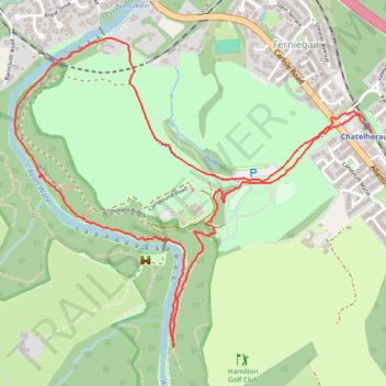
Loop Walk in Chatelherault Park
- Distance: 3.1 mi
- Elevation gain: 230 ft
- Maximum elevation: 276 ft
- Elevation loss: 236 ft
- Minimum elevation: 118 ft
- Moving time: 56 m 2 s
- Moving speed: 3.3 mph
- Maximum speed: 8.7 mph
- Total time: 58 m 12 s
- Global speed: 3.2 mph
Interactive trail map
Thank you for supporting this site ❤️
Make a donation
Make a donation
Gear up for your next adventure:
As an Amazon Associate, this site earns from qualifying purchases at no extra cost to you.
Trail profile
- Distance: 3.1 mi
- Elevation gain: 230 ft
- Maximum elevation: 276 ft
- Elevation loss: 236 ft
- Minimum elevation: 118 ft
- Moving time: 56 m 2 s
- Moving speed: 3.3 mph
- Maximum speed: 8.7 mph
- Total time: 58 m 12 s
- Global speed: 3.2 mph
Thank you for supporting this site ❤️
Make a donation
Make a donation
Gear up for your next adventure:
As an Amazon Associate, this site earns from qualifying purchases at no extra cost to you.
About this trail
Name: Loop Walk in Chatelherault Park trail, distance, elevation, map, profile, GPS track
Coordinates: 55.75748 -4.02608 55.76816 -4.00418
Thank you for supporting this site ❤️
Make a donation
Make a donation
Gear up for your next adventure:
As an Amazon Associate, this site earns from qualifying purchases at no extra cost to you.