Tremper Mountain
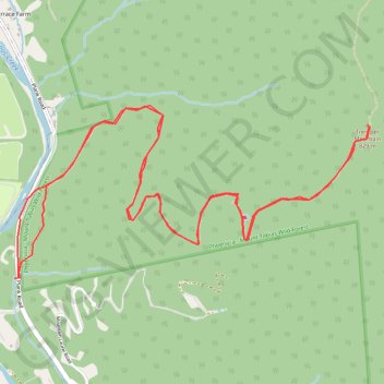
Hike to the Tremper Mountain Fire Tower via Phoenicia Trail in the Phoenicia - Mount Tobias Wild Forest. #Hiking #Mountain #Nature #Forest
- Distance: 6.2 mi
- Elevation gain: 2,064 ft
- Maximum elevation: 2,703 ft
- Elevation loss: 2,054 ft
- Minimum elevation: 764 ft
- Moving time: 2 h 30 m
- Moving speed: 2.5 mph
- Maximum speed: 16.1 mph
- Total time: 2 h 40 m
- Global speed: 2.3 mph
Interactive trail map
Trail profile
- Distance: 6.2 mi
- Elevation gain: 2,064 ft
- Maximum elevation: 2,703 ft
- Elevation loss: 2,054 ft
- Minimum elevation: 764 ft
- Moving time: 2 h 30 m
- Moving speed: 2.5 mph
- Maximum speed: 16.1 mph
- Total time: 2 h 40 m
- Global speed: 2.3 mph
About this trail
Name: Tremper Mountain trail, distance, elevation, map, profile, GPS track
Coordinates: 42.06619 -74.30354 42.07553 -74.27770
Topography: Ulster County topographic map, elevation, terrain