Thank you for supporting this site ❤️
Make a donation
Make a donation
Gear up for your next adventure:
As an Amazon Associate, this site earns from qualifying purchases at no extra cost to you.
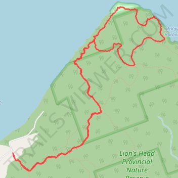
Lion's Head Bruce Trail Loop
- Distance: 6.8 mi
- Elevation gain: 1,001 ft
- Maximum elevation: 827 ft
- Elevation loss: 1,004 ft
- Minimum elevation: 571 ft
- Moving time: 2 h 35 m
- Moving speed: 2.6 mph
- Maximum speed: 7.5 mph
- Total time: 3 h 18 m
- Global speed: 2.1 mph
Interactive trail map
Thank you for supporting this site ❤️
Make a donation
Make a donation
Gear up for your next adventure:
As an Amazon Associate, this site earns from qualifying purchases at no extra cost to you.
Trail profile
- Distance: 6.8 mi
- Elevation gain: 1,001 ft
- Maximum elevation: 827 ft
- Elevation loss: 1,004 ft
- Minimum elevation: 571 ft
- Moving time: 2 h 35 m
- Moving speed: 2.6 mph
- Maximum speed: 7.5 mph
- Total time: 3 h 18 m
- Global speed: 2.1 mph
Thank you for supporting this site ❤️
Make a donation
Make a donation
Gear up for your next adventure:
As an Amazon Associate, this site earns from qualifying purchases at no extra cost to you.
About this trail
Name: Lion's Head Bruce Trail Loop trail, distance, elevation, map, profile, GPS track
Coordinates: 44.98746 -81.24213 45.00899 -81.21397
Thank you for supporting this site ❤️
Make a donation
Make a donation
Gear up for your next adventure:
As an Amazon Associate, this site earns from qualifying purchases at no extra cost to you.