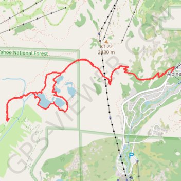
Five Lakes Loop
Starting at the Five Lakes Trailhead near Alpine Meadows Road, the route follows the Five Lakes Trail away from the developed valley and climbs through open Sierra slopes, scattered conifers, and granite-studded terrain toward the edge of Tahoe National Forest.
The path then enters the Granite Chief Wilderness, a protected mountain landscape known for its primitive character, forested basins, granite peaks, and non-motorized recreation, before reaching the Five Lakes Basin.
Around the lakes, optional detours trace quiet shorelines, small forest openings, granite outcrops, and the upper Five Lakes Creek area, creating a compact loop-style exploration before returning by the same mountain corridor to the trailhead.
#Hiking #Loop #Lake #Mountain #Nature #Forest #Wilderness #Creek
- Distance: 6.2 mi
- Elevation gain: 1,437 ft
- Maximum elevation: 7,602 ft
- Elevation loss: 1,437 ft
- Minimum elevation: 6,562 ft
- Moving time: 3 h 49 m
- Moving speed: 1.6 mph
- Maximum speed: 6.2 mph
- Total time: 7 h 18 m
- Global speed: 0.8 mph
Interactive trail map
Trail profile
- Distance: 6.2 mi
- Elevation gain: 1,437 ft
- Maximum elevation: 7,602 ft
- Elevation loss: 1,437 ft
- Minimum elevation: 6,562 ft
- Moving time: 3 h 49 m
- Moving speed: 1.6 mph
- Maximum speed: 6.2 mph
- Total time: 7 h 18 m
- Global speed: 0.8 mph
About this trail
Name: Five Lakes Loop trail, distance, elevation, map, profile, GPS track
Coordinates: 39.17198 -120.25915 39.18042 -120.22972
Topography: Placer County topographic map, elevation, terrain
Other hiking, mountain biking, running and outdoor activity trails
Click on a trail to view its statistics, map and profile.
Thunder Mountain Trail, Five Lakes Trail, Bear Creek Trail and Western States Trail Loop in Tahoe National Forest
United States > California > Placer County > Olympic Valley
Distance: 16.7 mi • Elevation gain: 3,865 ft • Maximum elevation: 7,726 ft
Broken Arrow 1-lapper
United States > California > Placer County > Olympic Valley
Distance: 14.5 mi • Elevation gain: 4,587 ft • Maximum elevation: 8,875 ft