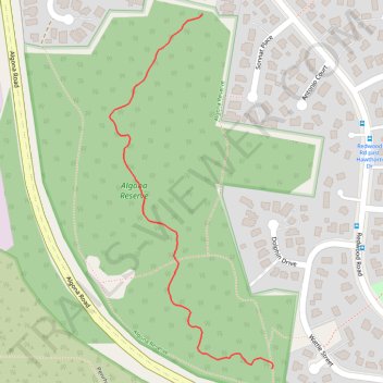
Algona Reserve Walking Track
- Distance: 0.5 mi
- Elevation gain: 43 ft
- Maximum elevation: 328 ft
- Elevation loss: 56 ft
- Minimum elevation: 269 ft
- Moving time: 9 m 59 s
- Moving speed: 3.1 mph
- Maximum speed: 4.7 mph
- Total time: 9 m 59 s
- Global speed: 3.1 mph
Interactive trail map
Trail profile
- Distance: 0.5 mi
- Elevation gain: 43 ft
- Maximum elevation: 328 ft
- Elevation loss: 56 ft
- Minimum elevation: 269 ft
- Moving time: 9 m 59 s
- Moving speed: 3.1 mph
- Maximum speed: 4.7 mph
- Total time: 9 m 59 s
- Global speed: 3.1 mph
About this trail
Name: Algona Reserve Walking Track trail, distance, elevation, map, profile, GPS track
Start: Tetratheca Drive, Redwood Village, Hobart, Tasmania, 7050, Australia (-42.99118 147.29795)
End: Algona Road, Huntingfield, Hobart, Tasmania, 7050, Australia (-42.99612 147.29927)
Coordinates: -42.99612 147.29619 -42.99118 147.29930