Make a donation
Gear up for your next adventure:
As an Amazon Associate, this site earns from qualifying purchases at no extra cost to you.
Eumundi Conservation Park
Interactive trail map
Make a donation
Gear up for your next adventure:
As an Amazon Associate, this site earns from qualifying purchases at no extra cost to you.
Trail profile
- Distance: 4.4 mi
- Elevation gain: 381 ft
- Maximum elevation: 259 ft
- Elevation loss: 381 ft
- Minimum elevation: 79 ft
Make a donation
Gear up for your next adventure:
As an Amazon Associate, this site earns from qualifying purchases at no extra cost to you.
About this trail
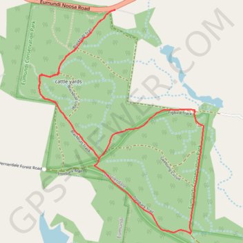
Name: Eumundi Conservation Park trail, distance, elevation, map, profile, GPS track
Start: Ajax Road, Verrierdale, Sunshine Coast Regional, Queensland, 4562, Australia (-26.47493 152.97744)
End: Ajax Road, Verrierdale, Sunshine Coast Regional, Queensland, 4562, Australia (-26.47492 152.97747)
Coordinates: -26.49234 152.97093 -26.47492 152.98518
Make a donation
Gear up for your next adventure:
As an Amazon Associate, this site earns from qualifying purchases at no extra cost to you.
Other hiking, mountain biking, running and outdoor activity trails
Click on a trail to view its statistics, map and profile.
Imbil Jimna Kenilworth loop
Australia > Queensland > Tewantin
Distance: 134.2 mi • Elevation gain: 12,743 ft • Maximum elevation: 2,697 ft