Make a donation
Gear up for your next adventure:
As an Amazon Associate, this site earns from qualifying purchases at no extra cost to you.
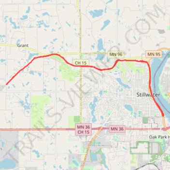
Brown's Creek State Trail
- Distance: 17.6 mi
- Elevation gain: 715 ft
- Maximum elevation: 1,020 ft
- Elevation loss: 715 ft
- Minimum elevation: 679 ft
- Moving time: 1 h 17 m
- Moving speed: 13.6 mph
- Maximum speed: 25.8 mph
- Total time: 1 h 17 m
- Global speed: 13.6 mph
Interactive trail map
Make a donation
Gear up for your next adventure:
As an Amazon Associate, this site earns from qualifying purchases at no extra cost to you.
Trail profile
- Distance: 17.6 mi
- Elevation gain: 715 ft
- Maximum elevation: 1,020 ft
- Elevation loss: 715 ft
- Minimum elevation: 679 ft
- Moving time: 1 h 17 m
- Moving speed: 13.6 mph
- Maximum speed: 25.8 mph
- Total time: 1 h 17 m
- Global speed: 13.6 mph
Make a donation
Gear up for your next adventure:
As an Amazon Associate, this site earns from qualifying purchases at no extra cost to you.
About this trail
Name: Brown's Creek State Trail trail, distance, elevation, map, profile, GPS track
Coordinates: 45.04344 -92.92388 45.07916 -92.79495
Topography: Washington County topographic map, elevation, terrain
Make a donation
Gear up for your next adventure:
As an Amazon Associate, this site earns from qualifying purchases at no extra cost to you.
Other hiking, mountain biking, running and outdoor activity trails
Click on a trail to view its statistics, map and profile.
Fairy Falls trail
United States > Minnesota > Washington County > Stillwater Township
Distance: 1.5 mi • Elevation gain: 240 ft • Maximum elevation: 837 ft