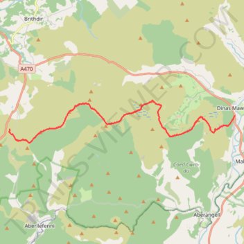
Dinas Mawddy to Cadair Idris
- Distance: 9.4 mi
- Elevation gain: 3,599 ft
- Maximum elevation: 2,208 ft
- Elevation loss: 2,808 ft
- Minimum elevation: 344 ft
- Moving time: 6 h 10 m
- Moving speed: 1.5 mph
- Maximum speed: 3.2 mph
- Total time: 7 h 35 m
- Global speed: 1.2 mph
Interactive trail map
Trail profile
- Distance: 9.4 mi
- Elevation gain: 3,599 ft
- Maximum elevation: 2,208 ft
- Elevation loss: 2,808 ft
- Minimum elevation: 344 ft
- Moving time: 6 h 10 m
- Moving speed: 1.5 mph
- Maximum speed: 3.2 mph
- Total time: 7 h 35 m
- Global speed: 1.2 mph
About this trail
Name: Dinas Mawddy to Cadair Idris trail, distance, elevation, map, profile, GPS track
Start: A470, Minllyn, Mawddwy, Dinas Mawddwy, Gwynedd, Wales, SY20 9LN, United Kingdom (52.71546 -3.69081)
End: A487, Dolgellau, Gwynedd, Wales, LL40 2RD, United Kingdom (52.70977 -3.83854)
Coordinates: 52.70450 -3.83869 52.72146 -3.69081