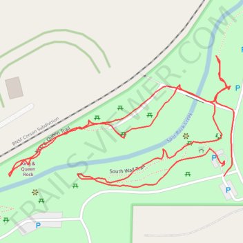
South Wall Trail and King & Queen Trail in Palisades State Park
- Distance: 1.3 mi
- Elevation gain: 131 ft
- Maximum elevation: 1,473 ft
- Elevation loss: 131 ft
- Minimum elevation: 1,407 ft
- Moving time: 43 m
- Moving speed: 1.9 mph
- Maximum speed: 3.4 mph
- Total time: 56 m 18 s
- Global speed: 1.4 mph
Interactive trail map
Trail profile
- Distance: 1.3 mi
- Elevation gain: 131 ft
- Maximum elevation: 1,473 ft
- Elevation loss: 131 ft
- Minimum elevation: 1,407 ft
- Moving time: 43 m
- Moving speed: 1.9 mph
- Maximum speed: 3.4 mph
- Total time: 56 m 18 s
- Global speed: 1.4 mph
About this trail
Name: South Wall Trail and King & Queen Trail in Palisades State Park trail, distance, elevation, map, profile, GPS track
Coordinates: 43.68743 -96.52274 43.68968 -96.51742
Topography: Minnehaha County topographic map, elevation, terrain