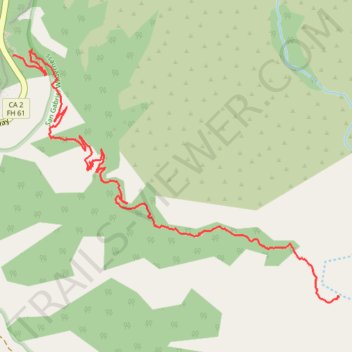
Devil's Canyon Trail - San Gabriel Wilderness
- Distance: 2.9 mi
- Elevation gain: 226 ft
- Maximum elevation: 5,318 ft
- Elevation loss: 1,601 ft
- Minimum elevation: 3,930 ft
- Moving time: 1 h 4 m
- Moving speed: 2.7 mph
- Maximum speed: 6.0 mph
- Total time: 1 h 21 m
- Global speed: 2.1 mph
Interactive trail map
Trail profile
- Distance: 2.9 mi
- Elevation gain: 226 ft
- Maximum elevation: 5,318 ft
- Elevation loss: 1,601 ft
- Minimum elevation: 3,930 ft
- Moving time: 1 h 4 m
- Moving speed: 2.7 mph
- Maximum speed: 6.0 mph
- Total time: 1 h 21 m
- Global speed: 2.1 mph
About this trail
Name: Devil's Canyon Trail - San Gabriel Wilderness trail, distance, elevation, map, profile, GPS track
Start: Devils Canyon Trail, Chilao, Los Angeles County, California, United States (34.32244 -118.00236)
End: Devils Canyon Trail, Los Angeles County, California, United States (34.31020 -117.98227)
Coordinates: 34.30985 -118.00236 34.32275 -117.98222
Topography: Los Angeles County topographic map, elevation, terrain