Carrickgollogan Wood loop
- Distance: 2.1 mi
- Elevation gain: 325 ft
- Maximum elevation: 810 ft
- Elevation loss: 325 ft
- Minimum elevation: 610 ft
- Moving time: 50 m 20 s
- Moving speed: 2.5 mph
- Maximum speed: 4.9 mph
- Total time: 52 m 59 s
- Global speed: 2.4 mph
Interactive trail map
Trail profile
- Distance: 2.1 mi
- Elevation gain: 325 ft
- Maximum elevation: 810 ft
- Elevation loss: 325 ft
- Minimum elevation: 610 ft
- Moving time: 50 m 20 s
- Moving speed: 2.5 mph
- Maximum speed: 4.9 mph
- Total time: 52 m 59 s
- Global speed: 2.4 mph
About this trail
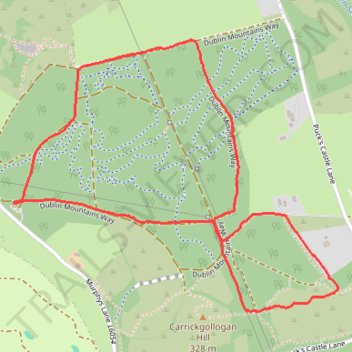
Name: Carrickgollogan Wood loop trail, distance, elevation, map, profile, GPS track
Coordinates: 53.21712 -6.16630 53.22479 -6.15095
Other hiking, mountain biking, running and outdoor activity trails
Click on a trail to view its statistics, map and profile.
Ballycorus leadmines mtb trails brush clearing
Ireland > County Dublin > Sandyford
Afternoon Mountain Bike Ride thinning brush clearing lower leadmines, opened up 2 old trails lower woods close to Rathmichael.
Distance: 16.0 mi • Elevation gain: 1,460 ft • Maximum elevation: 820 ft
Route1495
Ireland > County Dublin > Shankill
Distance: 24.1 mi • Elevation gain: 3,114 ft • Maximum elevation: 1,742 ft