Thank you for supporting this site ❤️
Make a donation
Make a donation
Gear up for your next adventure:
As an Amazon Associate, this site earns from qualifying purchases at no extra cost to you.
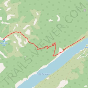
Lake Sylvester Hut from the Cobb Dam
- Distance: 3.4 mi
- Elevation gain: 1,703 ft
- Maximum elevation: 4,360 ft
- Elevation loss: 151 ft
- Minimum elevation: 2,703 ft
- Moving time: 1 h 49 m
- Moving speed: 1.9 mph
- Maximum speed: 3.2 mph
- Total time: 2 h 37 m
- Global speed: 1.3 mph
Interactive trail map
Thank you for supporting this site ❤️
Make a donation
Make a donation
Gear up for your next adventure:
As an Amazon Associate, this site earns from qualifying purchases at no extra cost to you.
Trail profile
- Distance: 3.4 mi
- Elevation gain: 1,703 ft
- Maximum elevation: 4,360 ft
- Elevation loss: 151 ft
- Minimum elevation: 2,703 ft
- Moving time: 1 h 49 m
- Moving speed: 1.9 mph
- Maximum speed: 3.2 mph
- Total time: 2 h 37 m
- Global speed: 1.3 mph
Thank you for supporting this site ❤️
Make a donation
Make a donation
Gear up for your next adventure:
As an Amazon Associate, this site earns from qualifying purchases at no extra cost to you.
About this trail
Name: Lake Sylvester Hut from the Cobb Dam trail, distance, elevation, map, profile, GPS track
Start: 2181, Cobb Dam Road, New Zealand (-41.10491 172.68336)
End: Sylvester Hut, BULLOCK TRACK, New Zealand (-41.10618 172.64440)
Coordinates: -41.11194 172.64402 -41.10311 172.68336
Thank you for supporting this site ❤️
Make a donation
Make a donation
Gear up for your next adventure:
As an Amazon Associate, this site earns from qualifying purchases at no extra cost to you.
Other hiking, mountain biking, running and outdoor activity trails
Click on a trail to view its statistics, map and profile.