Thank you for supporting this site ❤️
Make a donation
Make a donation
Gear up for your next adventure:
As an Amazon Associate, this site earns from qualifying purchases at no extra cost to you.
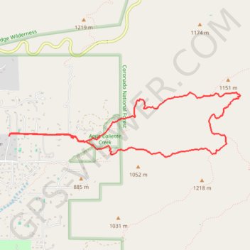
La Milagrosa Loop
Loop hike from Hohokam Estates via La Milagrosa in the Coronado National Forest. #Hiking #Loop #Mountain #Nature
- Distance: 6.2 mi
- Elevation gain: 1,437 ft
- Maximum elevation: 3,750 ft
- Elevation loss: 1,437 ft
- Minimum elevation: 2,782 ft
- Moving time: 3 h 3 m
- Moving speed: 2.0 mph
- Maximum speed: 3.4 mph
- Total time: 3 h 32 m
- Global speed: 1.7 mph
Interactive trail map
Thank you for supporting this site ❤️
Make a donation
Make a donation
Gear up for your next adventure:
As an Amazon Associate, this site earns from qualifying purchases at no extra cost to you.
Trail profile
- Distance: 6.2 mi
- Elevation gain: 1,437 ft
- Maximum elevation: 3,750 ft
- Elevation loss: 1,437 ft
- Minimum elevation: 2,782 ft
- Moving time: 3 h 3 m
- Moving speed: 2.0 mph
- Maximum speed: 3.4 mph
- Total time: 3 h 32 m
- Global speed: 1.7 mph
Thank you for supporting this site ❤️
Make a donation
Make a donation
Gear up for your next adventure:
As an Amazon Associate, this site earns from qualifying purchases at no extra cost to you.
About this trail
Name: La Milagrosa Loop trail, distance, elevation, map, profile, GPS track
Coordinates: 32.29509 -110.73076 32.30410 -110.69282
Topography: Pima County topographic map, elevation, terrain
Thank you for supporting this site ❤️
Make a donation
Make a donation
Gear up for your next adventure:
As an Amazon Associate, this site earns from qualifying purchases at no extra cost to you.