Thank you for supporting this site ❤️
Make a donation
Make a donation
Gear up for your next adventure:
As an Amazon Associate, this site earns from qualifying purchases at no extra cost to you.
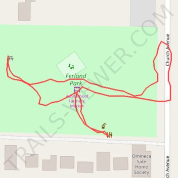
Ferland Park
- Distance: 0.3 mi
- Elevation gain: 10 ft
- Maximum elevation: 2,106 ft
- Elevation loss: 10 ft
- Minimum elevation: 2,096 ft
- Moving time: 8 m 16 s
- Moving speed: 2.4 mph
- Maximum speed: 4.6 mph
- Total time: 12 m 16 s
- Global speed: 1.6 mph
Interactive trail map
Thank you for supporting this site ❤️
Make a donation
Make a donation
Gear up for your next adventure:
As an Amazon Associate, this site earns from qualifying purchases at no extra cost to you.
Trail profile
- Distance: 0.3 mi
- Elevation gain: 10 ft
- Maximum elevation: 2,106 ft
- Elevation loss: 10 ft
- Minimum elevation: 2,096 ft
- Moving time: 8 m 16 s
- Moving speed: 2.4 mph
- Maximum speed: 4.6 mph
- Total time: 12 m 16 s
- Global speed: 1.6 mph
Thank you for supporting this site ❤️
Make a donation
Make a donation
Gear up for your next adventure:
As an Amazon Associate, this site earns from qualifying purchases at no extra cost to you.
About this trail
Name: Ferland Park trail, distance, elevation, map, profile, GPS track
Coordinates: 54.01744 -124.01357 54.01817 -124.01142
Thank you for supporting this site ❤️
Make a donation
Make a donation
Gear up for your next adventure:
As an Amazon Associate, this site earns from qualifying purchases at no extra cost to you.