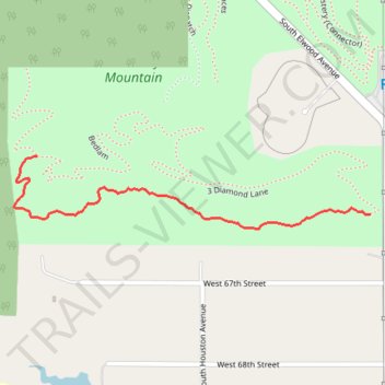
Turkey Mountain THE DAC MTB Trail
- Distance: 0.7 mi
- Elevation gain: 49 ft
- Maximum elevation: 814 ft
- Elevation loss: 56 ft
- Minimum elevation: 761 ft
- Moving time: 12 m 29 s
- Moving speed: 3.2 mph
- Maximum speed: 4.5 mph
- Total time: 12 m 29 s
- Global speed: 3.2 mph
Interactive trail map
Trail profile
- Distance: 0.7 mi
- Elevation gain: 49 ft
- Maximum elevation: 814 ft
- Elevation loss: 56 ft
- Minimum elevation: 761 ft
- Moving time: 12 m 29 s
- Moving speed: 3.2 mph
- Maximum speed: 4.5 mph
- Total time: 12 m 29 s
- Global speed: 3.2 mph
About this trail
Name: Turkey Mountain THE DAC MTB Trail trail, distance, elevation, map, profile, GPS track
Start: Checks and Balances, Tulsa, Tulsa County, Oklahoma, 74132, United States (36.06956 -96.00215)
End: 3 Diamond Lane, Tulsa, Tulsa County, Oklahoma, 74132, United States (36.06844 -95.99415)
Coordinates: 36.06816 -96.00269 36.06956 -95.99415
Topography: Tulsa topographic map, elevation, terrain
Other hiking, mountain biking, running and outdoor activity trails
Click on a trail to view its statistics, map and profile.
Turkey Mountain Rubble MTB Trail
United States > Oklahoma > Tulsa County > Tulsa
Distance: 0.9 mi • Elevation gain: 39 ft • Maximum elevation: 843 ft