Thank you for supporting this site ❤️
Make a donation
Make a donation
Gear up for your next adventure:
As an Amazon Associate, this site earns from qualifying purchases at no extra cost to you.
Thomas Hut via Bridle Path
- Distance: 4.1 mi
- Elevation gain: 3,278 ft
- Maximum elevation: 4,560 ft
- Elevation loss: 194 ft
- Minimum elevation: 1,444 ft
- Moving time: 2 h 32 m
- Moving speed: 1.6 mph
- Maximum speed: 3.0 mph
- Total time: 4 h 24 m
- Global speed: 0.9 mph
Interactive trail map
Thank you for supporting this site ❤️
Make a donation
Make a donation
Gear up for your next adventure:
As an Amazon Associate, this site earns from qualifying purchases at no extra cost to you.
Trail profile
- Distance: 4.1 mi
- Elevation gain: 3,278 ft
- Maximum elevation: 4,560 ft
- Elevation loss: 194 ft
- Minimum elevation: 1,444 ft
- Moving time: 2 h 32 m
- Moving speed: 1.6 mph
- Maximum speed: 3.0 mph
- Total time: 4 h 24 m
- Global speed: 0.9 mph
Thank you for supporting this site ❤️
Make a donation
Make a donation
Gear up for your next adventure:
As an Amazon Associate, this site earns from qualifying purchases at no extra cost to you.
About this trail
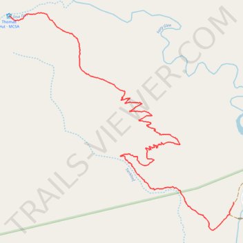
Name: Thomas Hut via Bridle Path trail, distance, elevation, map, profile, GPS track
Coordinates: -33.56911 19.40530 -33.54913 19.43010
Thank you for supporting this site ❤️
Make a donation
Make a donation
Gear up for your next adventure:
As an Amazon Associate, this site earns from qualifying purchases at no extra cost to you.