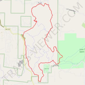
Loop Trails from Pine Flat via Poker Chip, Mahogany, Oak Flat, Sofa Queen and Deadman
- Distance: 10.0 mi
- Elevation gain: 804 ft
- Maximum elevation: 7,687 ft
- Elevation loss: 804 ft
- Minimum elevation: 7,224 ft
- Moving time: 1 h 26 m
- Moving speed: 6.9 mph
- Maximum speed: 20.1 mph
- Total time: 1 h 37 m
- Global speed: 6.2 mph
Interactive trail map
Trail profile
- Distance: 10.0 mi
- Elevation gain: 804 ft
- Maximum elevation: 7,687 ft
- Elevation loss: 804 ft
- Minimum elevation: 7,224 ft
- Moving time: 1 h 26 m
- Moving speed: 6.9 mph
- Maximum speed: 20.1 mph
- Total time: 1 h 37 m
- Global speed: 6.2 mph
About this trail
Name: Loop Trails from Pine Flat via Poker Chip, Mahogany, Oak Flat, Sofa Queen and Deadman trail, distance, elevation, map, profile, GPS track
Coordinates: 34.99025 -106.33722 35.03267 -106.31087
Topography: Bernalillo County topographic map, elevation, terrain
Other hiking, mountain biking, running and outdoor activity trails
Click on a trail to view its statistics, map and profile.
Oak Flat loop via Mahogany, Easy Pikin', Pine Loop and Gambel Oak in the Cibola National Forest
United States > New Mexico > Bernalillo County
Distance: 6.5 mi • Elevation gain: 492 ft • Maximum elevation: 7,700 ft
Poker Chip and Mahogany loop in the Cibola National Forest
United States > New Mexico > Bernalillo County > Cedro
Distance: 8.5 mi • Elevation gain: 935 ft • Maximum elevation: 7,533 ft
Bear Scat and Poker Chip Loop in Cibola National Forest
United States > New Mexico > Bernalillo County
Distance: 4.3 mi • Elevation gain: 466 ft • Maximum elevation: 7,756 ft
Pine Flats
United States > New Mexico > Bernalillo County
Distance: 19.1 mi • Elevation gain: 1,617 ft • Maximum elevation: 7,687 ft
Oak Flat
United States > New Mexico > Bernalillo County
Distance: 3.5 mi • Elevation gain: 335 ft • Maximum elevation: 7,707 ft