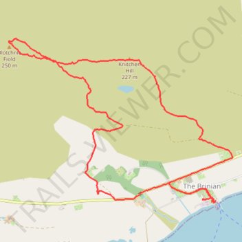
Hike up Blotchnie Fiold
- Distance: 5.1 mi
- Elevation gain: 876 ft
- Maximum elevation: 820 ft
- Elevation loss: 876 ft
- Minimum elevation: 3 ft
- Moving time: 2 h 14 m
- Moving speed: 2.3 mph
- Maximum speed: 4.8 mph
- Total time: 2 h 52 m
- Global speed: 1.8 mph
Interactive trail map
Trail profile
- Distance: 5.1 mi
- Elevation gain: 876 ft
- Maximum elevation: 820 ft
- Elevation loss: 876 ft
- Minimum elevation: 3 ft
- Moving time: 2 h 14 m
- Moving speed: 2.3 mph
- Maximum speed: 4.8 mph
- Total time: 2 h 52 m
- Global speed: 1.8 mph
About this trail
Name: Hike up Blotchnie Fiold trail, distance, elevation, map, profile, GPS track
End: B9065, The Brinian, Orkney Islands, Scotland, KW17 2PZ, United Kingdom (59.13067 -2.98625)
Coordinates: 59.13053 -3.01907 59.14389 -2.98360