
Fall Creek Mountain from Penner Lake via Island Lake and Feeley Lake
- Distance: 5.1 mi
- Elevation gain: 988 ft
- Maximum elevation: 7,457 ft
- Elevation loss: 1,240 ft
- Minimum elevation: 6,657 ft
- Moving time: 3 h 7 m
- Moving speed: 1.6 mph
- Maximum speed: 3.1 mph
- Total time: 6 h 31 m
- Global speed: 0.8 mph
Interactive trail map
Trail profile
- Distance: 5.1 mi
- Elevation gain: 988 ft
- Maximum elevation: 7,457 ft
- Elevation loss: 1,240 ft
- Minimum elevation: 6,657 ft
- Moving time: 3 h 7 m
- Moving speed: 1.6 mph
- Maximum speed: 3.1 mph
- Total time: 6 h 31 m
- Global speed: 0.8 mph
About this trail
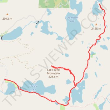
Name: Fall Creek Mountain from Penner Lake via Island Lake and Feeley Lake trail, distance, elevation, map, profile, GPS track
Start: Crooked Lake Trail, Nevada County, California, United States (39.41995 -120.61432)
End: Feeley Lake Road, Nevada County, California, United States (39.40214 -120.64330)
Coordinates: 39.39600 -120.64330 39.41995 -120.61246
Topography: Nevada County topographic map, elevation, terrain
Other hiking, mountain biking, running and outdoor activity trails
Click on a trail to view its statistics, map and profile.
Lindsey Lake to Five Lakes Basin Loop
United States > California > Nevada County
Loop hike between Lindsey Lake and Five Lakes Basin via Carr-Lindsey Road, Middle Lindsey Dam, Culbertson Lake, Lindsey Lake Trail, Lower Rock Lake, Rock Lake, Crooked Lake Trail, Penner Lake, Crooked Lakes, Island Lake, Round Lake Trail, Long Lake, Round Lake, Milk Lake, Grouse Ridge Trail, Sand Ridge Trail,…
Distance: 23.5 mi • Elevation gain: 3,425 ft • Maximum elevation: 7,592 ft