Make a donation
Gear up for your next adventure:
As an Amazon Associate, this site earns from qualifying purchases at no extra cost to you.
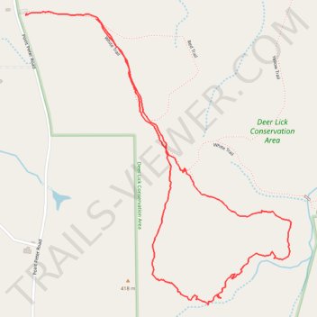
Deer Lick Conservation Area Orange Trail Loop
- Distance: 2.0 mi
- Elevation gain: 194 ft
- Maximum elevation: 1,355 ft
- Elevation loss: 187 ft
- Minimum elevation: 1,234 ft
- Moving time: 1 h 13 m
- Moving speed: 1.7 mph
- Maximum speed: 3.1 mph
- Total time: 1 h 27 m
- Global speed: 1.4 mph
Interactive trail map
Make a donation
Gear up for your next adventure:
As an Amazon Associate, this site earns from qualifying purchases at no extra cost to you.
Trail profile
- Distance: 2.0 mi
- Elevation gain: 194 ft
- Maximum elevation: 1,355 ft
- Elevation loss: 187 ft
- Minimum elevation: 1,234 ft
- Moving time: 1 h 13 m
- Moving speed: 1.7 mph
- Maximum speed: 3.1 mph
- Total time: 1 h 27 m
- Global speed: 1.4 mph
Make a donation
Gear up for your next adventure:
As an Amazon Associate, this site earns from qualifying purchases at no extra cost to you.
About this trail
Name: Deer Lick Conservation Area Orange Trail Loop trail, distance, elevation, map, profile, GPS track
Start: White Trail, Town of Persia, Cattaraugus County, New York, United States (42.41993 -78.90515)
End: White Trail, Town of Persia, Cattaraugus County, New York, 14070, United States (42.41977 -78.90225)
Coordinates: 42.41091 -78.90521 42.41999 -78.89405
Topography: Cattaraugus County topographic map, elevation, terrain
Make a donation
Gear up for your next adventure:
As an Amazon Associate, this site earns from qualifying purchases at no extra cost to you.