Make a donation
Gear up for your next adventure:
As an Amazon Associate, this site earns from qualifying purchases at no extra cost to you.
Return from Bridge to Nowhere
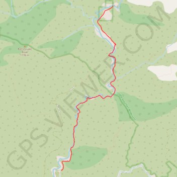
- Distance: 4.8 mi
- Elevation gain: 728 ft
- Maximum elevation: 2,871 ft
- Elevation loss: 1,539 ft
- Minimum elevation: 2,005 ft
- Moving time: 1 h 53 m
- Moving speed: 2.5 mph
- Maximum speed: 6.2 mph
- Total time: 2 h 19 m
- Global speed: 2.1 mph
Interactive trail map
Make a donation
Gear up for your next adventure:
As an Amazon Associate, this site earns from qualifying purchases at no extra cost to you.
Trail profile
- Distance: 4.8 mi
- Elevation gain: 728 ft
- Maximum elevation: 2,871 ft
- Elevation loss: 1,539 ft
- Minimum elevation: 2,005 ft
- Moving time: 1 h 53 m
- Moving speed: 2.5 mph
- Maximum speed: 6.2 mph
- Total time: 2 h 19 m
- Global speed: 2.1 mph
Make a donation
Gear up for your next adventure:
As an Amazon Associate, this site earns from qualifying purchases at no extra cost to you.
About this trail
Name: Return from Bridge to Nowhere trail, distance, elevation, map, profile, GPS track
Start: East Fork Trail, Los Angeles County, California, United States (34.28286 -117.74722)
End: East Fork Road, Los Angeles County, California, United States (34.23718 -117.76472)
Coordinates: 34.23718 -117.76472 34.28293 -117.74620
Topography: Los Angeles County topographic map, elevation, terrain
Make a donation
Gear up for your next adventure:
As an Amazon Associate, this site earns from qualifying purchases at no extra cost to you.
Other hiking, mountain biking, running and outdoor activity trails
Click on a trail to view its statistics, map and profile.
Bridge to Nowhere
United States > California > Los Angeles County
Distance: 9.5 mi • Elevation gain: 1,847 ft • Maximum elevation: 2,835 ft