Thank you for supporting this site ❤️
Make a donation
Make a donation
Gear up for your next adventure:
As an Amazon Associate, this site earns from qualifying purchases at no extra cost to you.
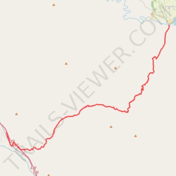
Lookout Mountain Road
- Distance: 27.3 mi
- Elevation gain: 4,042 ft
- Maximum elevation: 5,344 ft
- Elevation loss: 4,636 ft
- Minimum elevation: 2,103 ft
- Moving time: 1 h 57 m
- Moving speed: 14.0 mph
- Maximum speed: 50.1 mph
- Total time: 2 h 20 m
- Global speed: 11.6 mph
Interactive trail map
Thank you for supporting this site ❤️
Make a donation
Make a donation
Gear up for your next adventure:
As an Amazon Associate, this site earns from qualifying purchases at no extra cost to you.
Trail profile
- Distance: 27.3 mi
- Elevation gain: 4,042 ft
- Maximum elevation: 5,344 ft
- Elevation loss: 4,636 ft
- Minimum elevation: 2,103 ft
- Moving time: 1 h 57 m
- Moving speed: 14.0 mph
- Maximum speed: 50.1 mph
- Total time: 2 h 20 m
- Global speed: 11.6 mph
Thank you for supporting this site ❤️
Make a donation
Make a donation
Gear up for your next adventure:
As an Amazon Associate, this site earns from qualifying purchases at no extra cost to you.
About this trail
Name: Lookout Mountain Road trail, distance, elevation, map, profile, GPS track
Start: 35902, Lang Road, Durkee, Baker County, Oregon, 97905, United States (44.60051 -117.47466)
End: Daly Creek Road, Baker County, Oregon, United States (44.74372 -117.17007)
Coordinates: 44.57665 -117.47466 44.74372 -117.16855
Topography: Baker County topographic map, elevation, terrain
Thank you for supporting this site ❤️
Make a donation
Make a donation
Gear up for your next adventure:
As an Amazon Associate, this site earns from qualifying purchases at no extra cost to you.