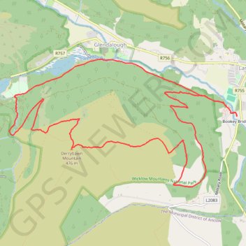
Derrybawn Mountain Loop
- Distance: 8.0 mi
- Elevation gain: 1,470 ft
- Maximum elevation: 1,529 ft
- Elevation loss: 1,470 ft
- Minimum elevation: 417 ft
- Moving time: 2 h 36 m
- Moving speed: 3.1 mph
- Maximum speed: 6.5 mph
- Total time: 3 h 10 m
- Global speed: 2.5 mph
Interactive trail map
Trail profile
- Distance: 8.0 mi
- Elevation gain: 1,470 ft
- Maximum elevation: 1,529 ft
- Elevation loss: 1,470 ft
- Minimum elevation: 417 ft
- Moving time: 2 h 36 m
- Moving speed: 3.1 mph
- Maximum speed: 6.5 mph
- Total time: 3 h 10 m
- Global speed: 2.5 mph
About this trail
Name: Derrybawn Mountain Loop trail, distance, elevation, map, profile, GPS track
Coordinates: 52.99349 -6.34704 53.00944 -6.29977
Other hiking, mountain biking, running and outdoor activity trails
Click on a trail to view its statistics, map and profile.
The Glendalough Hike - Wicklow Mountains National Park
Ireland > County Wicklow > Bookey Bridge
Distance: 11.7 mi • Elevation gain: 2,087 ft • Maximum elevation: 1,650 ft
Moonlight Challenge
Distance: 16.1 mi • Elevation gain: 3,199 ft • Maximum elevation: 1,660 ft
Glenealo Valley
Distance: 16.0 mi • Elevation gain: 3,074 ft • Maximum elevation: 1,654 ft