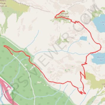
Mount Defiance Trail via Ira Spring Trail and Mason Lake in Alpine Lakes Wilderness
The Mount Defiance Trail is a challenging yet rewarding hike within Washington’s Alpine Lakes Wilderness. Starting with steep switchbacks, the trail weaves through lush forests before offering a break at the serene Mason Lake, surrounded by evergreen peaks and often reflecting the sky. The final ascent to Mount Defiance is demanding but culminates in panoramic views of rugged peaks, valleys, and, on clear days, even Mount Rainier. #Hiking #Mountain #Lake #Forest #Nature
- Distance: 10.0 mi
- Elevation gain: 3,855 ft
- Maximum elevation: 5,420 ft
- Elevation loss: 3,845 ft
- Minimum elevation: 2,142 ft
Interactive trail map
Trail profile
- Distance: 10.0 mi
- Elevation gain: 3,855 ft
- Maximum elevation: 5,420 ft
- Elevation loss: 3,845 ft
- Minimum elevation: 2,142 ft
About this trail
Name: Mount Defiance Trail via Ira Spring Trail and Mason Lake in Alpine Lakes Wilderness trail, distance, elevation, map, profile, GPS track
Start: Ira Spring Trail, King County, Washington, United States (47.42489 -121.58367)
End: Ira Spring Trailhead, Mason Lake Road, King County, Washington, United States (47.42455 -121.58315)
Coordinates: 47.41488 -121.58637 47.43543 -121.55087
Topography: King County topographic map, elevation, terrain
Other hiking, mountain biking, running and outdoor activity trails
Click on a trail to view its statistics, map and profile.
Island Lake via Ira Spring Trail, Mason Lake and Mount Defiance Trail in Alpine Lakes Wilderness
United States > Washington > King County
Distance: 5.2 mi • Elevation gain: 2,687 ft • Maximum elevation: 4,472 ft
Northern part of the Pacific Crest Trail (PCT)
United States > Oregon > Klamath County
Hike on the Pacific Crest National Scenic Trail from Crater Lake to Canada Border through Oregon and Washington along the Sierra Nevada and Cascade mountain ranges. #Hiking #Mountain #SierraNevada #Cascade #Nature #Forest #Park #PCT
Distance: 744.6 mi • Elevation gain: 145,367 ft • Maximum elevation: 7,569 ft
Mount Defiance from Island Lake in Alpine Lakes Wilderness
United States > Washington > King County
Distance: 5.7 mi • Elevation gain: 1,808 ft • Maximum elevation: 5,420 ft