Make a donation
Gear up for your next adventure:
As an Amazon Associate, this site earns from qualifying purchases at no extra cost to you.
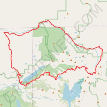
Mt. Margaret to Green River Escape
- Distance: 45.1 mi
- Elevation gain: 8,389 ft
- Maximum elevation: 5,709 ft
- Elevation loss: 8,392 ft
- Minimum elevation: 1,549 ft
- Moving time: 7 h 17 m
- Moving speed: 6.2 mph
- Maximum speed: 41.0 mph
- Total time: 8 h 17 m
- Global speed: 5.4 mph
Interactive trail map
Make a donation
Gear up for your next adventure:
As an Amazon Associate, this site earns from qualifying purchases at no extra cost to you.
Trail profile
- Distance: 45.1 mi
- Elevation gain: 8,389 ft
- Maximum elevation: 5,709 ft
- Elevation loss: 8,392 ft
- Minimum elevation: 1,549 ft
- Moving time: 7 h 17 m
- Moving speed: 6.2 mph
- Maximum speed: 41.0 mph
- Total time: 8 h 17 m
- Global speed: 5.4 mph
Make a donation
Gear up for your next adventure:
As an Amazon Associate, this site earns from qualifying purchases at no extra cost to you.
About this trail
Name: Mt. Margaret to Green River Escape trail, distance, elevation, map, profile, GPS track
Coordinates: 46.28296 -122.31284 46.39768 -122.06296
Topography: Cowlitz County topographic map, elevation, terrain
Make a donation
Gear up for your next adventure:
As an Amazon Associate, this site earns from qualifying purchases at no extra cost to you.
Other hiking, mountain biking, running and outdoor activity trails
Click on a trail to view its statistics, map and profile.
Northern part of the Pacific Crest Trail (PCT)
United States > Oregon > Klamath County
Hike on the Pacific Crest National Scenic Trail from Crater Lake to Canada Border through Oregon and Washington along the Sierra Nevada and Cascade mountain ranges. #Hiking #Mountain #SierraNevada #Cascade #Nature #Forest #Park #PCT
Distance: 744.6 mi • Elevation gain: 145,367 ft • Maximum elevation: 7,569 ft
Goat Mountain and Green River Secrets
United States > Washington > Skamania County
Green river trail western section
Distance: 27.0 mi • Elevation gain: 5,571 ft • Maximum elevation: 5,020 ft
Coldwater Lake to Iron Creek Campground
United States > Washington > Cowlitz County
Gravel
Distance: 44.2 mi • Elevation gain: 6,690 ft • Maximum elevation: 3,225 ft