Thank you for supporting this site ❤️
Make a donation
Make a donation
Gear up for your next adventure:
As an Amazon Associate, this site earns from qualifying purchases at no extra cost to you.
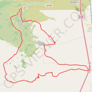
Socorro ride
Afternoon gravel ride
- Distance: 31.7 mi
- Elevation gain: 2,500 ft
- Maximum elevation: 5,810 ft
- Elevation loss: 2,500 ft
- Minimum elevation: 4,652 ft
- Moving time: 3 h 15 m
- Moving speed: 9.7 mph
- Maximum speed: 27.2 mph
- Total time: 3 h 40 m
- Global speed: 8.6 mph
Interactive trail map
Thank you for supporting this site ❤️
Make a donation
Make a donation
Gear up for your next adventure:
As an Amazon Associate, this site earns from qualifying purchases at no extra cost to you.
Trail profile
- Distance: 31.7 mi
- Elevation gain: 2,500 ft
- Maximum elevation: 5,810 ft
- Elevation loss: 2,500 ft
- Minimum elevation: 4,652 ft
- Moving time: 3 h 15 m
- Moving speed: 9.7 mph
- Maximum speed: 27.2 mph
- Total time: 3 h 40 m
- Global speed: 8.6 mph
Thank you for supporting this site ❤️
Make a donation
Make a donation
Gear up for your next adventure:
As an Amazon Associate, this site earns from qualifying purchases at no extra cost to you.
About this trail
Name: Socorro ride trail, distance, elevation, map, profile, GPS track
Start: Torreon Spring Road, Socorro County, New Mexico, United States (33.98472 -106.99050)
End: Torreon Spring Road, Socorro County, New Mexico, United States (33.98481 -106.99050)
Coordinates: 33.89912 -107.02251 34.00171 -106.88103
Topography: Socorro County topographic map, elevation, terrain
Thank you for supporting this site ❤️
Make a donation
Make a donation
Gear up for your next adventure:
As an Amazon Associate, this site earns from qualifying purchases at no extra cost to you.