Make a donation
Gear up for your next adventure:
As an Amazon Associate, this site earns from qualifying purchases at no extra cost to you.
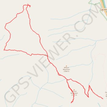
Wilson Mountain Summit Loop (Red Rock-Secret Mountain Wilderness)
Loop hike on Wilson Mountain via Wilson Mountain Trail, Sedona Overlook and Canyon Overlook in the Red Rock-Secret Mountain Wilderness. #Hiking #Loop #Mountain #Nature #Overlook #Forest #Wilderness
- Distance: 6.7 mi
- Elevation gain: 1,371 ft
- Maximum elevation: 7,014 ft
- Elevation loss: 1,371 ft
- Minimum elevation: 6,273 ft
- Moving time: 3 h 1 m
- Moving speed: 2.2 mph
- Maximum speed: 3.5 mph
- Total time: 3 h 34 m
- Global speed: 1.9 mph
Interactive trail map
Make a donation
Gear up for your next adventure:
As an Amazon Associate, this site earns from qualifying purchases at no extra cost to you.
Trail profile
- Distance: 6.7 mi
- Elevation gain: 1,371 ft
- Maximum elevation: 7,014 ft
- Elevation loss: 1,371 ft
- Minimum elevation: 6,273 ft
- Moving time: 3 h 1 m
- Moving speed: 2.2 mph
- Maximum speed: 3.5 mph
- Total time: 3 h 34 m
- Global speed: 1.9 mph
Make a donation
Gear up for your next adventure:
As an Amazon Associate, this site earns from qualifying purchases at no extra cost to you.
About this trail
Name: Wilson Mountain Summit Loop (Red Rock-Secret Mountain Wilderness) trail, distance, elevation, map, profile, GPS track
Start: North Wilson Trail, Coconino County, Arizona, United States (34.91043 -111.74100)
End: Wilson Mountain Trail, Coconino County, Arizona, United States (34.91045 -111.74104)
Coordinates: 34.90948 -111.76798 34.93162 -111.74100
Topography: Coconino County topographic map, elevation, terrain
Make a donation
Gear up for your next adventure:
As an Amazon Associate, this site earns from qualifying purchases at no extra cost to you.