Thank you for supporting this site ❤️
Make a donation
Make a donation
Gear up for your next adventure:
As an Amazon Associate, this site earns from qualifying purchases at no extra cost to you.
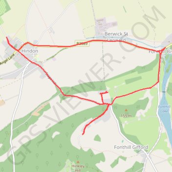
Hindon - Fonthill Gifford loop
Bit of a struggle today but nice route. Stopped too early on Stop Street though :)
- Distance: 5.3 mi
- Elevation gain: 528 ft
- Maximum elevation: 509 ft
- Elevation loss: 528 ft
- Minimum elevation: 335 ft
- Moving time: 47 m 12 s
- Moving speed: 6.7 mph
- Maximum speed: 12.1 mph
- Total time: 47 m 59 s
- Global speed: 6.6 mph
Interactive trail map
Thank you for supporting this site ❤️
Make a donation
Make a donation
Gear up for your next adventure:
As an Amazon Associate, this site earns from qualifying purchases at no extra cost to you.
Trail profile
- Distance: 5.3 mi
- Elevation gain: 528 ft
- Maximum elevation: 509 ft
- Elevation loss: 528 ft
- Minimum elevation: 335 ft
- Moving time: 47 m 12 s
- Moving speed: 6.7 mph
- Maximum speed: 12.1 mph
- Total time: 47 m 59 s
- Global speed: 6.6 mph
Thank you for supporting this site ❤️
Make a donation
Make a donation
Gear up for your next adventure:
As an Amazon Associate, this site earns from qualifying purchases at no extra cost to you.
About this trail
Name: Hindon - Fonthill Gifford loop trail, distance, elevation, map, profile, GPS track
Start: Hindon, Wiltshire, England, SP3 6DJ, United Kingdom (51.09596 -2.13130)
End: Hindon, Wiltshire, England, SP3 6DJ, United Kingdom (51.09595 -2.13117)
Coordinates: 51.08293 -2.13200 51.09700 -2.09541
Thank you for supporting this site ❤️
Make a donation
Make a donation
Gear up for your next adventure:
As an Amazon Associate, this site earns from qualifying purchases at no extra cost to you.