Thank you for supporting this site ❤️
Make a donation
Make a donation
Gear up for your next adventure:
As an Amazon Associate, this site earns from qualifying purchases at no extra cost to you.
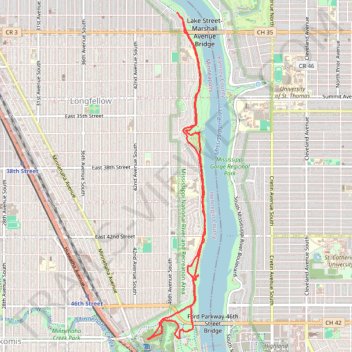
Winchell trail, Minneapolis, MN
- Distance: 6.1 mi
- Elevation gain: 456 ft
- Maximum elevation: 827 ft
- Elevation loss: 449 ft
- Minimum elevation: 751 ft
- Moving time: 2 h 2 m
- Moving speed: 3.0 mph
- Maximum speed: 7.1 mph
- Total time: 2 h 6 m
- Global speed: 2.9 mph
Interactive trail map
Thank you for supporting this site ❤️
Make a donation
Make a donation
Gear up for your next adventure:
As an Amazon Associate, this site earns from qualifying purchases at no extra cost to you.
Trail profile
- Distance: 6.1 mi
- Elevation gain: 456 ft
- Maximum elevation: 827 ft
- Elevation loss: 449 ft
- Minimum elevation: 751 ft
- Moving time: 2 h 2 m
- Moving speed: 3.0 mph
- Maximum speed: 7.1 mph
- Total time: 2 h 6 m
- Global speed: 2.9 mph
Thank you for supporting this site ❤️
Make a donation
Make a donation
Gear up for your next adventure:
As an Amazon Associate, this site earns from qualifying purchases at no extra cost to you.
About this trail
Name: Winchell trail, Minneapolis, MN trail, distance, elevation, map, profile, GPS track
Coordinates: 44.91619 -93.21088 44.95033 -93.20232
Topography: Minneapolis topographic map, elevation, terrain
Thank you for supporting this site ❤️
Make a donation
Make a donation
Gear up for your next adventure:
As an Amazon Associate, this site earns from qualifying purchases at no extra cost to you.