Make a donation
Gear up for your next adventure:
As an Amazon Associate, this site earns from qualifying purchases at no extra cost to you.
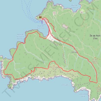
PORT-CROS, BOUCLE SUD-OUEST
- Distance: 5.2 mi
- Elevation gain: 1,263 ft
- Maximum elevation: 564 ft
- Elevation loss: 1,260 ft
- Minimum elevation: 0 ft
- Moving time: 2 h 46 m
- Moving speed: 1.9 mph
- Maximum speed: 2.0 mph
- Total time: 2 h 46 m
- Global speed: 1.9 mph
Interactive trail map
Make a donation
Gear up for your next adventure:
As an Amazon Associate, this site earns from qualifying purchases at no extra cost to you.
Trail profile
- Distance: 5.2 mi
- Elevation gain: 1,263 ft
- Maximum elevation: 564 ft
- Elevation loss: 1,260 ft
- Minimum elevation: 0 ft
- Moving time: 2 h 46 m
- Moving speed: 1.9 mph
- Maximum speed: 2.0 mph
- Total time: 2 h 46 m
- Global speed: 1.9 mph
Make a donation
Gear up for your next adventure:
As an Amazon Associate, this site earns from qualifying purchases at no extra cost to you.
About this trail
Name: PORT-CROS, BOUCLE SUD-OUEST trail, distance, elevation, map, profile, GPS track
Coordinates: 42.99689 6.37083 43.01040 6.39730
Make a donation
Gear up for your next adventure:
As an Amazon Associate, this site earns from qualifying purchases at no extra cost to you.
Other hiking, mountain biking, running and outdoor activity trails
Click on a trail to view its statistics, map and profile.
1 LUCENA - MONTPELLIER
Distance: 1,842.0 mi • Elevation gain: 96,785 ft • Maximum elevation: 3,438 ft
PT23DS2 Lörrach → Cadaqués
Germany > Baden-Württemberg > Landkreis Lörrach > Lörrach (Kernstadt)
Distance: 652.9 mi • Elevation gain: 43,077 ft • Maximum elevation: 4,938 ft
PORT-CROS, BOUCLE NORD-EST
France > Provence-Alpes-Côte d'Azur > Var > Hyères > Port-Cros
Distance: 6.5 mi • Elevation gain: 1,742 ft • Maximum elevation: 623 ft