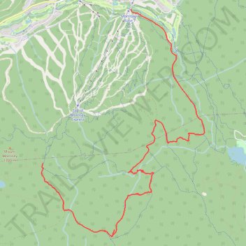
Mount Morrisey Backcountry Ski trails
Got a little off route at top of fisher and on bruin romp
- Distance: 6.1 mi
- Elevation gain: 164 ft
- Maximum elevation: 5,394 ft
- Elevation loss: 1,355 ft
- Minimum elevation: 4,199 ft
- Moving time: 2 h 18 m
- Moving speed: 2.7 mph
- Maximum speed: 23.0 mph
- Total time: 3 h 8 m
- Global speed: 2.0 mph
Interactive trail map
Trail profile
- Distance: 6.1 mi
- Elevation gain: 164 ft
- Maximum elevation: 5,394 ft
- Elevation loss: 1,355 ft
- Minimum elevation: 4,199 ft
- Moving time: 2 h 18 m
- Moving speed: 2.7 mph
- Maximum speed: 23.0 mph
- Total time: 3 h 8 m
- Global speed: 2.0 mph
About this trail
Name: Mount Morrisey Backcountry Ski trails trail, distance, elevation, map, profile, GPS track
Coordinates: 50.84807 -119.89327 50.88180 -119.85502
Other hiking, mountain biking, running and outdoor activity trails
Click on a trail to view its statistics, map and profile.
Sun Peaks Nordic Backcountry Ski Trails
Canada > British Columbia > Thompson-Nicola Regional District > Sun Peaks Mountain Resort Municipality > Sun Peaks
Distance: 11.2 mi • Elevation gain: 1,207 ft • Maximum elevation: 4,734 ft