Thank you for supporting this site ❤️
Make a donation
Make a donation
Gear up for your next adventure:
As an Amazon Associate, this site earns from qualifying purchases at no extra cost to you.
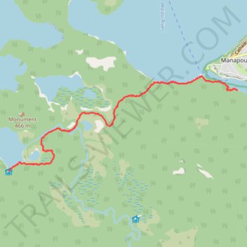
Manapouri to Hope Arm Hut
- Distance: 5.5 mi
- Elevation gain: 482 ft
- Maximum elevation: 810 ft
- Elevation loss: 489 ft
- Minimum elevation: 604 ft
- Moving time: 2 h 22 m
- Moving speed: 2.3 mph
- Maximum speed: 3.3 mph
- Total time: 2 h 32 m
- Global speed: 2.2 mph
Interactive trail map
Thank you for supporting this site ❤️
Make a donation
Make a donation
Gear up for your next adventure:
As an Amazon Associate, this site earns from qualifying purchases at no extra cost to you.
Trail profile
- Distance: 5.5 mi
- Elevation gain: 482 ft
- Maximum elevation: 810 ft
- Elevation loss: 489 ft
- Minimum elevation: 604 ft
- Moving time: 2 h 22 m
- Moving speed: 2.3 mph
- Maximum speed: 3.3 mph
- Total time: 2 h 32 m
- Global speed: 2.2 mph
Thank you for supporting this site ❤️
Make a donation
Make a donation
Gear up for your next adventure:
As an Amazon Associate, this site earns from qualifying purchases at no extra cost to you.
About this trail
Name: Manapouri to Hope Arm Hut trail, distance, elevation, map, profile, GPS track
Coordinates: -45.58989 167.54149 -45.56885 167.61411
Thank you for supporting this site ❤️
Make a donation
Make a donation
Gear up for your next adventure:
As an Amazon Associate, this site earns from qualifying purchases at no extra cost to you.
Other hiking, mountain biking, running and outdoor activity trails
Click on a trail to view its statistics, map and profile.
Hope Arm Hut to Manapouri
New Zealand > Southland > Southland District > Fiordland Community
Distance: 5.5 mi • Elevation gain: 495 ft • Maximum elevation: 810 ft