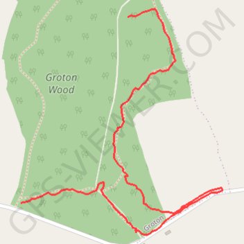
Groton Wood Nature Reserve
- Distance: 0.9 mi
- Elevation gain: 49 ft
- Maximum elevation: 236 ft
- Elevation loss: 36 ft
- Minimum elevation: 210 ft
- Moving time: 19 m 47 s
- Moving speed: 2.6 mph
- Maximum speed: 5.7 mph
- Total time: 19 m 47 s
- Global speed: 2.6 mph
Interactive trail map
Trail profile
- Distance: 0.9 mi
- Elevation gain: 49 ft
- Maximum elevation: 236 ft
- Elevation loss: 36 ft
- Minimum elevation: 210 ft
- Moving time: 19 m 47 s
- Moving speed: 2.6 mph
- Maximum speed: 5.7 mph
- Total time: 19 m 47 s
- Global speed: 2.6 mph
About this trail
Name: Groton Wood Nature Reserve trail, distance, elevation, map, profile, GPS track
Start: Bulmer Lane, Groton, Boxford, Babergh, Suffolk, England, CO10 5EZ, United Kingdom (52.05256 0.88411)
End: Bulmer Lane, Groton, Boxford, Babergh, Suffolk, England, CO10 5EZ, United Kingdom (52.04900 0.88079)
Coordinates: 52.04839 0.88079 52.05271 0.88706