Thank you for supporting this site ❤️
Make a donation
Make a donation
Gear up for your next adventure:
As an Amazon Associate, this site earns from qualifying purchases at no extra cost to you.
2014-06-22 14:03:54
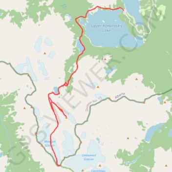
- Distance: 26.3 mi
- Elevation gain: 8,930 ft
- Maximum elevation: 11,224 ft
- Elevation loss: 8,953 ft
- Minimum elevation: 5,581 ft
- Moving time: 14 h 48 m
- Moving speed: 1.8 mph
- Maximum speed: 4.9 mph
- Total time: 1 d 5 h
- Global speed: 0.9 mph
Interactive trail map
Thank you for supporting this site ❤️
Make a donation
Make a donation
Gear up for your next adventure:
As an Amazon Associate, this site earns from qualifying purchases at no extra cost to you.
Trail profile
- Distance: 26.3 mi
- Elevation gain: 8,930 ft
- Maximum elevation: 11,224 ft
- Elevation loss: 8,953 ft
- Minimum elevation: 5,581 ft
- Moving time: 14 h 48 m
- Moving speed: 1.8 mph
- Maximum speed: 4.9 mph
- Total time: 1 d 5 h
- Global speed: 0.9 mph
Thank you for supporting this site ❤️
Make a donation
Make a donation
Gear up for your next adventure:
As an Amazon Associate, this site earns from qualifying purchases at no extra cost to you.
About this trail
Name: 2014-06-22 14:03:54 trail, distance, elevation, map, profile, GPS track
Start: Three Isle Lake Trail, Kananaskis Improvement District, Alberta, Canada (50.63307 -115.14563)
End: North Interlakes Loop Road, Kananaskis Improvement District, Alberta, Canada (50.63186 -115.14002)
Coordinates: 50.52832 -115.21929 50.63452 -115.14002
Thank you for supporting this site ❤️
Make a donation
Make a donation
Gear up for your next adventure:
As an Amazon Associate, this site earns from qualifying purchases at no extra cost to you.