Make a donation
Gear up for your next adventure:
As an Amazon Associate, this site earns from qualifying purchases at no extra cost to you.
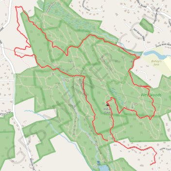
Revised Red Triangle Trail in Westwoods, Guilford CT
- Distance: 5.8 mi
- Elevation gain: 466 ft
- Maximum elevation: 144 ft
- Elevation loss: 453 ft
- Minimum elevation: 46 ft
- Moving time: 3 h 45 s
- Moving speed: 1.9 mph
- Maximum speed: 3.6 mph
- Total time: 3 h 11 m
- Global speed: 1.8 mph
Interactive trail map
Make a donation
Gear up for your next adventure:
As an Amazon Associate, this site earns from qualifying purchases at no extra cost to you.
Trail profile
- Distance: 5.8 mi
- Elevation gain: 466 ft
- Maximum elevation: 144 ft
- Elevation loss: 453 ft
- Minimum elevation: 46 ft
- Moving time: 3 h 45 s
- Moving speed: 1.9 mph
- Maximum speed: 3.6 mph
- Total time: 3 h 11 m
- Global speed: 1.8 mph
Make a donation
Gear up for your next adventure:
As an Amazon Associate, this site earns from qualifying purchases at no extra cost to you.
About this trail
Name: Revised Red Triangle Trail in Westwoods, Guilford CT trail, distance, elevation, map, profile, GPS track
Coordinates: 41.27442 -72.72331 41.29256 -72.70154
Topography: South Central Connecticut Planning Region topographic map, elevation, terrain
Make a donation
Gear up for your next adventure:
As an Amazon Associate, this site earns from qualifying purchases at no extra cost to you.
Other hiking, mountain biking, running and outdoor activity trails
Click on a trail to view its statistics, map and profile.
Westwoods green triangle and square near Dunk Rock Road
United States > Connecticut > South Central Connecticut Planning Region > Guilford
Distance: 2.8 mi • Elevation gain: 223 ft • Maximum elevation: 118 ft
Westwoods in Guilford CT
United States > Connecticut > South Central Connecticut Planning Region > Guilford
Distance: 3.4 mi • Elevation gain: 253 ft • Maximum elevation: 115 ft