Thank you for supporting this site ❤️
Make a donation
Make a donation
Gear up for your next adventure:
As an Amazon Associate, this site earns from qualifying purchases at no extra cost to you.
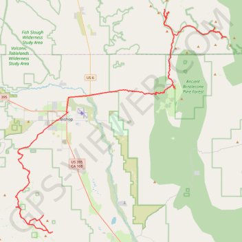
Crooked Creek
- Distance: 74.6 mi
- Elevation gain: 12,500 ft
- Maximum elevation: 11,857 ft
- Elevation loss: 12,907 ft
- Minimum elevation: 4,091 ft
Interactive trail map
Thank you for supporting this site ❤️
Make a donation
Make a donation
Gear up for your next adventure:
As an Amazon Associate, this site earns from qualifying purchases at no extra cost to you.
Trail profile
- Distance: 74.6 mi
- Elevation gain: 12,500 ft
- Maximum elevation: 11,857 ft
- Elevation loss: 12,907 ft
- Minimum elevation: 4,091 ft
Thank you for supporting this site ❤️
Make a donation
Make a donation
Gear up for your next adventure:
As an Amazon Associate, this site earns from qualifying purchases at no extra cost to you.
About this trail
Name: Crooked Creek trail, distance, elevation, map, profile, GPS track
Start: Coyote Flats to Piper Peak Trail, Inyo County, California, United States (37.22817 -118.49273)
End: Crooked Creek Road, Mono County, California, United States (37.49734 -118.10716)
Coordinates: 37.18840 -118.49331 37.53227 -118.08618
Topography: Inyo County topographic map, elevation, terrain
Thank you for supporting this site ❤️
Make a donation
Make a donation
Gear up for your next adventure:
As an Amazon Associate, this site earns from qualifying purchases at no extra cost to you.