Sunrise on Perins Ridge
- Distance: 3.4 mi
- Elevation gain: 735 ft
- Maximum elevation: 7,497 ft
- Elevation loss: 827 ft
- Minimum elevation: 6,703 ft
- Moving time: 1 h 23 m
- Moving speed: 2.4 mph
- Maximum speed: 4.7 mph
- Total time: 1 h 28 m
- Global speed: 2.3 mph
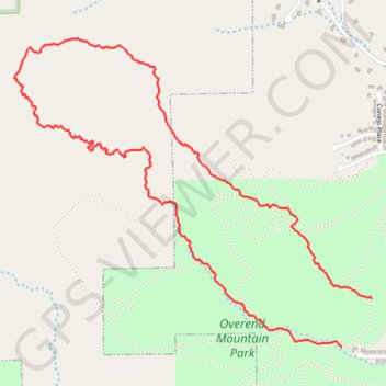
Interactive trail map
Trail profile
- Distance: 3.4 mi
- Elevation gain: 735 ft
- Maximum elevation: 7,497 ft
- Elevation loss: 827 ft
- Minimum elevation: 6,703 ft
- Moving time: 1 h 23 m
- Moving speed: 2.4 mph
- Maximum speed: 4.7 mph
- Total time: 1 h 28 m
- Global speed: 2.3 mph
About this trail
Name: Sunrise on Perins Ridge trail, distance, elevation, map, profile, GPS track
Start: Ned's Hill, Durango, La Plata County, Colorado, 80131, United States (37.28671 -107.88752)
End: Perins Gulch Trail, Durango, La Plata County, Colorado, 80131, United States (37.28468 -107.88910)
Coordinates: 37.28468 -107.90626 37.29757 -107.88752
Topography: Durango topographic map, elevation, terrain
Other hiking, mountain biking, running and outdoor activity trails
Click on a trail to view its statistics, map and profile.
Overend Mountain Park loop trails
United States > Colorado > La Plata County > Durango
Distance: 7.0 mi • Elevation gain: 951 ft • Maximum elevation: 7,057 ft
Animas Mountain
United States > Colorado > La Plata County > Durango
Distance: 12.5 mi • Elevation gain: 2,159 ft • Maximum elevation: 8,061 ft