Thank you for supporting this site ❤️
Make a donation
Make a donation
Gear up for your next adventure:
As an Amazon Associate, this site earns from qualifying purchases at no extra cost to you.
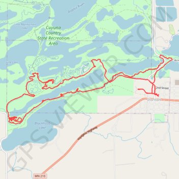
Cuyuna MTB Loop
Mountain Bike loop in Cuyuna Country State Recreation Area. #MTB #Loop #Lake #Forest #Nature
- Distance: 9.5 mi
- Elevation gain: 577 ft
- Maximum elevation: 1,289 ft
- Elevation loss: 577 ft
- Minimum elevation: 1,201 ft
- Moving time: 1 h 23 m
- Moving speed: 6.8 mph
- Maximum speed: 21.2 mph
- Total time: 1 h 23 m
- Global speed: 6.8 mph
Interactive trail map
Thank you for supporting this site ❤️
Make a donation
Make a donation
Gear up for your next adventure:
As an Amazon Associate, this site earns from qualifying purchases at no extra cost to you.
Trail profile
- Distance: 9.5 mi
- Elevation gain: 577 ft
- Maximum elevation: 1,289 ft
- Elevation loss: 577 ft
- Minimum elevation: 1,201 ft
- Moving time: 1 h 23 m
- Moving speed: 6.8 mph
- Maximum speed: 21.2 mph
- Total time: 1 h 23 m
- Global speed: 6.8 mph
Thank you for supporting this site ❤️
Make a donation
Make a donation
Gear up for your next adventure:
As an Amazon Associate, this site earns from qualifying purchases at no extra cost to you.
About this trail
Name: Cuyuna MTB Loop trail, distance, elevation, map, profile, GPS track
Coordinates: 46.47255 -94.02053 46.48631 -93.97238
Topography: Crow Wing County topographic map, elevation, terrain
Thank you for supporting this site ❤️
Make a donation
Make a donation
Gear up for your next adventure:
As an Amazon Associate, this site earns from qualifying purchases at no extra cost to you.