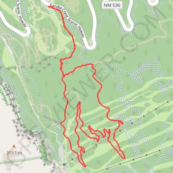
King of the Mountain Loop Trail in Cibola National Forest
- Distance: 3.8 mi
- Elevation gain: 722 ft
- Maximum elevation: 10,187 ft
- Elevation loss: 722 ft
- Minimum elevation: 9,810 ft
- Moving time: 1 h 33 m
- Moving speed: 2.5 mph
- Maximum speed: 4.1 mph
- Total time: 1 h 40 m
- Global speed: 2.3 mph
Interactive trail map
Trail profile
- Distance: 3.8 mi
- Elevation gain: 722 ft
- Maximum elevation: 10,187 ft
- Elevation loss: 722 ft
- Minimum elevation: 9,810 ft
- Moving time: 1 h 33 m
- Moving speed: 2.5 mph
- Maximum speed: 4.1 mph
- Total time: 1 h 40 m
- Global speed: 2.3 mph
About this trail
Name: King of the Mountain Loop Trail in Cibola National Forest trail, distance, elevation, map, profile, GPS track
Coordinates: 35.19670 -106.43554 35.20920 -106.42826
Topography: Bernalillo County topographic map, elevation, terrain
Other hiking, mountain biking, running and outdoor activity trails
Click on a trail to view its statistics, map and profile.
La Luz Trail in Sandia Mountain Wilderness
United States > New Mexico > Sandoval County
The La Luz Trail is a breathtaking journey that transforms from high desert landscapes to lush pine forests as you ascend toward Sandia Peak. Hikers are treated to stunning panoramic views of Albuquerque and the surrounding mountains, especially near the scenic overlook, where wildflowers add a splash of color…
Distance: 15.4 mi • Elevation gain: 4,698 ft • Maximum elevation: 10,299 ft
Challenge Trail
United States > New Mexico > Bernalillo County
Distance: 14.2 mi • Elevation gain: 797 ft • Maximum elevation: 10,643 ft