Make a donation
Gear up for your next adventure:
As an Amazon Associate, this site earns from qualifying purchases at no extra cost to you.
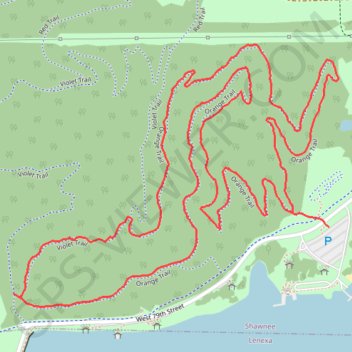
Orange Loop Trail in Shawnee Mission Park
The Orange Loop Trail offers a pleasant and accessible hiking experience through a well-maintained forest environment. As you navigate the loop, you'll encounter a mix of shaded paths, diverse tree cover, and scenic spots ideal for birdwatching and enjoying the tranquility of nature. The trail is suitable for a variety of users, including hikers and mountain bikers, making it a versatile choice for outdoor enthusiasts. #Hiking #Loop #Forest #Nature
- Distance: 3.1 mi
- Elevation gain: 197 ft
- Maximum elevation: 988 ft
- Elevation loss: 180 ft
- Minimum elevation: 892 ft
- Moving time: 1 h 29 s
- Moving speed: 3.1 mph
- Maximum speed: 8.6 mph
- Total time: 1 h 29 s
- Global speed: 3.1 mph
Interactive trail map
Make a donation
Gear up for your next adventure:
As an Amazon Associate, this site earns from qualifying purchases at no extra cost to you.
Trail profile
- Distance: 3.1 mi
- Elevation gain: 197 ft
- Maximum elevation: 988 ft
- Elevation loss: 180 ft
- Minimum elevation: 892 ft
- Moving time: 1 h 29 s
- Moving speed: 3.1 mph
- Maximum speed: 8.6 mph
- Total time: 1 h 29 s
- Global speed: 3.1 mph
Make a donation
Gear up for your next adventure:
As an Amazon Associate, this site earns from qualifying purchases at no extra cost to you.
About this trail
Name: Orange Loop Trail in Shawnee Mission Park trail, distance, elevation, map, profile, GPS track
Start: West 79th Street, Shawnee, Johnson County, Kansas, 66219, United States (38.98788 -94.80002)
End: Orange Trail, Shawnee, Johnson County, Kansas, 66218, United States (38.98822 -94.80113)
Coordinates: 38.98601 -94.80954 38.99216 -94.79974
Topography: Shawnee topographic map, elevation, terrain
Make a donation
Gear up for your next adventure:
As an Amazon Associate, this site earns from qualifying purchases at no extra cost to you.
Other hiking, mountain biking, running and outdoor activity trails
Click on a trail to view its statistics, map and profile.
Violet Loop Trail in Shawnee Mission Park
United States > Kansas > Johnson County > Shawnee
The Violet Loop Trail offers a serene hiking experience amidst diverse wildlife and lush vegetation, featuring both shaded wooded areas and open fields. Hikers can enjoy a well-maintained path that is engaging due to its moderate elevation changes and rocky terrain, providing a pleasant challenge for outdoor…
Distance: 2.4 mi • Elevation gain: 148 ft • Maximum elevation: 978 ft